
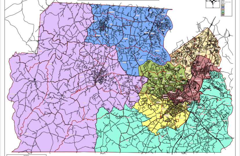
York County is postponing a county council vote on proposed voting line changes that come after the 2020 census report. The county is currently divided into seven districts that incorporate the towns of Clover, Fort Mill, Hickory Grove, McConnells, Sharon, Smyrna, Rock Hill, Tega Cay and York.
The districts that would see the most changes are districts one, two, three and five due to population shifts since the last census, according to Greg Suskin, public information officer for the York County government.
The census is taken every 10 years to determine the amount of US House representatives each state gets and “also to determine the population of city council wards and state legislative districts,” Dr. John Holder, professor of political science at Winthrop University, said.
Since York County is continuing to grow, “the council wards have to be adjusted so that each ward ends up with as close to the same number of people as possible. There’s been a lot of growth on the north side, coming down from Charlotte and Fort Mill, and not so much on the south side,” Holder said.
Tom Audette, the councilman from district one which covers northern Fort Mill and Tega Cay, “will actually see his district shrink due to the large population growth in Fort Mill and Tega Cay,” Suskin said.
The council has spent a lot of time debating different maps and boundaries, often down to the neighborhood or street to ensure as much equal representation as possible. The council will be voting again on the map next Tuesday.
“I believe the changes that we will be voting on Tuesday will meet all required criteria and I agree with the changes that will be voted on Tuesday evening,” Councilman Robert Winkler, representative for district three, which covers all of the primarily rural western York County, said.
Winkler will have a larger area of York County to represent since his district had a slower population growth than others. The same changes are being made to districts two and five due to slow population growth.
According to Holder, when drawing the map, the council members must make sure they are not gerrymandering, which is “the practice of drawing the boundaries of electoral districts in a way that gives one political party an unfair advantage over its rivals or that dilutes the voting power of members of ethnic or linguistic minority groups,” according to the Encyclopaedia Britannica.
“The main consideration under the Voting Rights Act of 1965 is whether Black voters are adequately represented on the Council,” Holder said, “The population of Rock Hill is 39% Black, and two of the six wards have majority-Black populations, so that means that council as a group will continue to be reasonably representative of the city population as a whole.”
The district to see the most changes will be district one, as many Charlotte residents have moved to the upper Fort Mill area.
Once the council has officially voted on the map, the new voting lines will be in place for the next ten years.